Randonnée Marche La Ciotat - la ciotat le pont naturek - Photo
 Cirannaantoine
Cirannaantoine

Utilisateur

© OpenStreetMap contributors
Longueur
Longueur
9,2 km
Altitude max
Altitude max
380 m
Dénivelé positif
Dénivelé positif
495 m
Km-Effort
Km-Effort  
15,9 km
Altitude min
Altitude min
86 m
Dénivelé négatif
Dénivelé négatif
502 m
Boucle
Boucle
Oui
Date de création :
2019-02-12 10:11:11.087
Dernière modification :
2019-02-12 16:19:33.966

(0 Avis)

Marche
Marche
6h03
Difficulté : Moyen

Scannez ce code QR pour ouvrir la randonnée dans l'application SityTrail

Application GPS de randonnée GRATUITE

Logo SityTrail SityTrail

IGN / Instituts géographiques

Télécharger SityTrail sur l'App Store Télécharger SityTrail sur Google Play

Logo SityTrail SityTrail World

Le monde est à vous

Télécharger SityTrail sur l'App Store Télécharger SityTrail sur Google Play Télécharger SityTrail sur Huawei AppGallery

À propos

Randonnée Marche de 9,2 km à découvrir à Provence-Alpes-Côte d'Azur, Bouches-du-Rhône, La Ciotat. Cette randonnée est proposée par Cirannaantoine.

Description

2 étoiles

Profil altimétrique

Photos

Localisation

Pays :
France
Région :
Provence-Alpes-Côte d'Azur
Département/Province :
Bouches-du-Rhône
Commune :
La Ciotat
Localité :
Unknown
Départ:(UTM)
710327 ; 4785173 (31T) N.

Randonnées à proximité

Randonnée Vélo de route Cassis - Marseille Cassis Route - Photo
Vélo de route
GUIDE+

Vélo de route

Moyen
(1)
Cassis, Provence-Alpes-Côte d'Azur, Bouches-du-Rhône, France
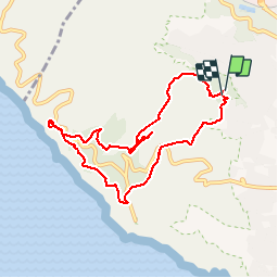
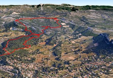
21 km | 26 km-effort
1h 31min
Non
Randonnée Marche Ceyreste - Autour du Montounier 2eme version - Photo
Marche
GUIDE
affinetataille

Marche

Moyen
(1)
Ceyreste, Provence-Alpes-Côte d'Azur, Bouches-du-Rhône, France
15,7 km | 24 km-effort
6h 0min
Oui
Randonnée Marche Cassis - Cassis - La couronne de Charlemagne - Cap canaille - Photo
Marche
GUIDE
affinetataille

Marche

Moyen
(3)
Cassis, Provence-Alpes-Côte d'Azur, Bouches-du-Rhône, France
16,1 km | 24 km-effort
6h 0min
Oui
Randonnée Marche La Ciotat - La Ciotat - Chapelle Ste Anne - Ruines villas - Semaphore - Bau Rous - Pont naturel - Dent du chat - Photo
Marche
GUIDE
affinetataille

Marche

Difficile
(1)
La Ciotat, Provence-Alpes-Côte d'Azur, Bouches-du-Rhône, France
12,1 km | 19,9 km-effort
7h 30min
Oui
Randonnée Marche La Ciotat - la ciotat - Photo
Marche
Berrangerannick

Marche

Très facile
(1)
La Ciotat, Provence-Alpes-Côte d'Azur, Bouches-du-Rhône, France
6,2 km | 9,3 km-effort
3h 21min
Oui
Randonnée Marche Cassis - les calanques de Cassis - Photo
Marche
th.feur

Marche

Moyen
(1)
Cassis, Provence-Alpes-Côte d'Azur, Bouches-du-Rhône, France
15,9 km | 23 km-effort
6h 2min
Non
Randonnée Marche Cassis - Rando Cassis - Mont Gibaou - Photo
Marche
tracegps

Marche

Difficile
(4)
Cassis, Provence-Alpes-Côte d'Azur, Bouches-du-Rhône, France
9,2 km | 14,3 km-effort
3h 0min
Oui
Randonnée Marche Cassis - Autour du Mont Gibaou  - Photo
Marche
GUIDE
affinetataille

Marche

Moyen
Cassis, Provence-Alpes-Côte d'Azur, Bouches-du-Rhône, France
12,5 km | 18,7 km-effort
6h 0min
Oui
Randonnée Marche La Ciotat - Balade La Ciotat  - Photo
Marche
BADEY

Marche

Difficile
(1)
La Ciotat, Provence-Alpes-Côte d'Azur, Bouches-du-Rhône, France
8,8 km | 14 km-effort
3h 7min
Oui


Fermer
Mes abonnements